As the area is faced with the increasing presence of Red Tide, we compiled some resources from FWC for you to review the latest information about areas affected and what to do.
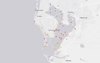
Daily Sample Map
This map contains the last eight days of sampling and is updated daily at 5 p.m. Please be sure to click on individual dots for sampling details.
Red Tide Current Status
FWC reports on the current status of Karenia brevis blooms using tables, static maps, and interactive Google Earth maps. Archived status maps can be found in our Flickr gallery.
Red Tide-Related Hotlines and Information Sources
Report a fish kill or other wildlife effects, consult health authorities about human exposure, or locate other resources.
Red Tide FAQ
Do you have questions about Florida’s red tide? Find the answers here.
HAB General Information
Learn about algae blooms in Florida, including red tide.
Tools for Tracking Red Tides
FWC scientists combine field sampling with tools maintained by state and federal partners to track red tides and their effects.
Harmful Algal Bloom/Red Tide Task Force
The Harmful Algal Bloom/Red Tide Task Force will play an important role in determining strategies to research, monitor, control and mitigate red tide and other harmful algal blooms in Florida waters.


